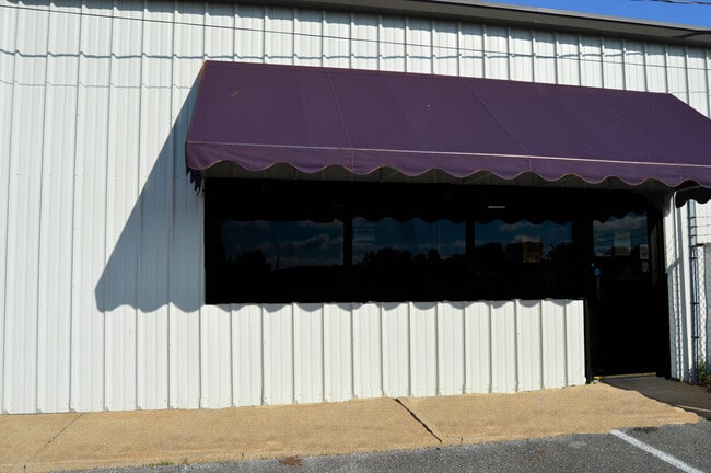
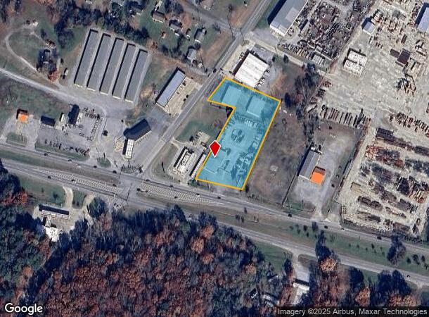
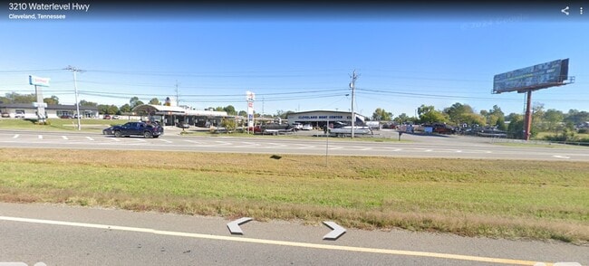
Property Record
3125 Waterlevel Hwy, Cleveland, TN 37323
NEARBY LISTINGS FOR SALE OR LEASE
Property Detail
3125 Waterlevel Hwy
Cleveland, TN
Ayers Property
058F-D-012.00
AYERS PROPERTY PB: 12 PG: 80 LOT: 2 CLEVELAND BOAT CENTER 220 X 343.6 IRR
Commercialnec
Bradley
X
Tennessee
47011C0139E
2
2024
1 AC
2025
Tennessee East Area
010300
Other Market Areas
15,360 SF
DEMOGRAPHICS near 3125 Waterlevel Hwy
1 Mile
3 Mile
5 Mile
2024 Total Population
1,743
38,564
72,397
2029 Population
1,848
40,641
76,240
Pop Growth 2024-2029
+ 6.02%
+ 5.39%
+ 5.31%
Average Age
39
38
39
2024 Total Households
688
14,884
28,173
HH Growth 2024-2029
+ 5.81%
+ 5.70%
+ 5.51%
Median Household Inc
$47,500
$46,178
$51,026
Avg Household Size
2.50
2.40
2.50
2024 Avg HH Vehicles
2.00
2.00
2.00
Median Home Value
$182,960
$191,861
$198,935
Median Year Built
1981
1983
1983
Nearby Places
Map Layers
Map Styles
 Street
 Aerial
- Restaurants
- Banks
- Shops
- Fitness
- Groceries
PUBLIC TRANSPORTATION
AIRPORT
Lovell Field
DRIVE
WALK
Distance
Lovell Field
39 min
27.2 mi
SALE & LEASE HISTORY
LISTING DATE
SALE/LEASE

Jul 24, 2024
For Sale
Jan 09, 2025
For Sale
Nearby Properties
Address
Land Use
TOTAL SIZE
Lot Size
Zoning
Address
Land Use
TOTAL SIZE
Lot Size
Zoning
400,000 SF
123.44 AC
IH
Address
Land Use
TOTAL SIZE
Lot Size
Zoning
357,110 SF
52.96 AC
FAR
Address
Land Use
TOTAL SIZE
Lot Size
Zoning
267,460 SF
8.30 AC
IL
Address
Land Use
TOTAL SIZE
Lot Size
Zoning
178,664 SF
14.80 AC
IH
Address
Land Use
TOTAL SIZE
Lot Size
Zoning
118,230 SF
37 AC
FAR
Address
Land Use
TOTAL SIZE
Lot Size
Zoning
68,785 SF
8.70 AC
R1
Address
Land Use
TOTAL SIZE
Lot Size
Zoning
356,920 SF
26.42 AC
IL
Address
Land Use
TOTAL SIZE
Lot Size
Zoning
65,382 SF
63.70 AC
FAR
Address
Land Use
TOTAL SIZE
Lot Size
Zoning
74,392 SF
15.69 AC
MU
Address
Land Use
TOTAL SIZE
Lot Size
Zoning
203,778 SF
13.46 AC
R3
Address
Land Use
TOTAL SIZE
Lot Size
Zoning
50,400 SF
1.04 AC
CBD
Address
Land Use
TOTAL SIZE
Lot Size
Zoning
196,358 SF
16.50 AC
A
Address
Land Use
TOTAL SIZE
Lot Size
Zoning
74,229 SF
1 AC
R1
Address
Land Use
TOTAL SIZE
Lot Size
Zoning
421,180 SF
27.10 AC
IL
Address
Land Use
TOTAL SIZE
Lot Size
Zoning
48,494 SF
4.70 AC
R3
Address
Land Use
TOTAL SIZE
Lot Size
Zoning
82,628 SF
9.50 AC
R3
Address
Land Use
TOTAL SIZE
Lot Size
Zoning
56,725 SF
13.10 AC
R1
Address
Land Use
TOTAL SIZE
Lot Size
Zoning
205,800 SF
30.93 AC
CH
Address
Land Use
TOTAL SIZE
Lot Size
Zoning
30,526 SF
0.92 AC
CBD
Address
Land Use
TOTAL SIZE
Lot Size
Zoning
122,596 SF
5.98 AC
PUD
Address
Land Use
TOTAL SIZE
Lot Size
Zoning
104,319 SF
2.63 AC
IH
Address
Land Use
TOTAL SIZE
Lot Size
Zoning
23,022 SF
1.68 AC
HP
Address
Land Use
TOTAL SIZE
Lot Size
Zoning
24,948 SF
4.76 AC
PI
Address
Land Use
TOTAL SIZE
Lot Size
Zoning
10,000 SF
83.16 AC
MU
Address
Land Use
TOTAL SIZE
Lot Size
Zoning
82,190 SF
6.53 AC
PI
Address
Land Use
TOTAL SIZE
Lot Size
Zoning
22,004 SF
5.30 AC
R2
Address
Land Use
TOTAL SIZE
Lot Size
Zoning
18,912 SF
1.22 AC
CBD
Address
Land Use
TOTAL SIZE
Lot Size
Zoning
122,792 SF
12.85 AC
R3
Address
Land Use
TOTAL SIZE
Lot Size
Zoning
57,408 SF
0.08 AC
CBD
Address
Land Use
TOTAL SIZE
Lot Size
Zoning
97,208 SF
12.20 AC
R3
The World's #1 Commercial Real Estate Marketplace
Connect with us
© 2025 CoStar Group
The information above has been obtained from sources believed reliable. While we do not doubt its accuracy we have not verified it and make no guarantee, warranty or representation about it. It is your responsibility to independently confirm its accuracy and completeness. Any projections, opinions, assumptions, or estimates used are for example only and do not represent the current or future performance of the property. The value of this transaction to you depends on tax and other factors which should be evaluated by your tax, financial, and legal advisors. You and your advisors should conduct a careful, independent investigation of the property to determine to your satisfaction the suitability of the property for your needs.